
Research Article
Austin J Earth Sci. 2014;1(1): 7.
Ecological Consequences of Shrimp Farming in Southwestern Satkhira District of Bangladesh
Md. Humayun Kabir*, Iffat Jahan Eva
Department of Geography and Environment, University of Dhaka, Bangladesh
*Corresponding author: :Md. Humayun Kabir, Department of Geography and Environment, University of Dhaka, Dhaka 1000, Bangladesh
Received: June 02, 2014; Accepted: July 21, 2014; Published: July 26, 2014
Abstract
The present study based on primary investigations (focus group discussion, field observation, household interviews etc.), laboratory analyses for soil and water quality (heavy metal test, pH, salinity, electricity conductivity, particle size analysis etc.) and secondary materials (remote sensing data, satellite images analysis etc.) reveals that due to poor drainage system and continuous shrimp farming at Chandipur Village under Debhata Upazila of Satkhira District, salinity level of both soil and water are increasing. In addition PH, salinity, electrical conductivity of soil and water have been found in a very critical condition. Different types of heavy and toxic metals such as Na, Fe, Cr, Zn, Ni, and Pb have been detected in ghers’ soil. However, to reduce such toxic concentration in water and soil, measures to introduce drainage system (to control water quality and discharge effluents from ghers), to control the use of fish-feed, to stop further conversion of land into gher and to promote plantation of local species have to be adopted.
Keywords: Ecological impacts; Soil & water quality; Shrimp farming; Satkhira; Bangladesh
Introduction
Fisheries in Bangladesh is one of the major contributors to the agricultural GDP (22.21%) and 2.73% to foreign exchange earnings by exporting fish products during 2010-11. Within this sector, shrimp (Penaeus monodon) is the dominant contributor [1,2]. In parallel with the large contribution of shrimp farming to local and national economy, it has already caused significant damages to the local ecosystems [3-5]. More than 15.6 million people of the country are directly and indirectly involved in this sector. During the last few decades shrimp aquaculture, particularly the black tiger shrimp (Bagda) has been a major component in the development of our national economy. Coastal aquaculture is mainly based on shrimp cultivation, while shrimp is the second largest source of earning foreign currency [6]. Among exported fishes only shrimp contributed 57 percent during 2010-2011. Bangladesh has a huge coastal tidal area which is considered favourable for shrimp farming and 0.276 million hectares of land are currently under brackish water shrimp cultivation. During 2010-2011 the country produced 182,471 metric tons of large (121,203 metric tons) and small shrimp [7] and earned US$ 437.40 million from both frozen shrimp and fishes [8]. South-western and south-eastern parts of the country are favourable for shrimp cultivation. Coastal shrimp culture however, is mainly concentrated in the districts of Khulna and Chittagong. Most of the lands of this region are now under shrimp cultivation. Moreover, three districts of Bangladesh (Khulna, Bagerhat and Satkhira) accommodate around 80 percent of total shrimp production [9,10]. Since 1980s shrimp has been a major part of aquaculture in this region and is considered as the major driving force of economic development in this area. Two-thirds of the farms in Khulna region (southwestern part) rotate paddy with shrimp cultivation, while in highly saline condition of Chittagong region (southeastern part), salt is commonly rotated with shrimp [11]. In addition, different climatic variables including cyclone, salinity, sea level rise, water temperature, flood, rainfall, and drought have had adverse effects on coastal ecosystem [5].
Shrimp aquaculture has been causing severe threats to local ecological systems, such as- deterioration of soil and water quality, depletion of mangrove forest, decrease of local variety of rice and fish, saline water intrusion in ground water, local water pollution and change of local hydrology [12-15]. Recent extensive expansion of shrimp cultivation has severely caused depletion of forest cover of the Chokoria-Sundarbans and led to significant losses of biodiversity of fisheries and forest species [16,17]. Salinization in ground water and saline water intrusion in surrounding areas have caused a serious ecological and socioeconomic damage in the coastal environment. Salinity is being thought to be a silent poison in the southwestern part of Bangladesh due to continuous shrimp cultivation. In this region, the practices of shrimp farming have caused massive loss of crop production, loss of fruit and other indigenous floral species, fresh water crisis for drinking and so on [10]. The absence of national policy and strategy on sustainable shrimp aquaculture has been a fundamental problem of this sector [3]. Gradual increase of toxic elements in the soil of this region is contaminating lower level soil. Products of this soil also carry these toxic substances and have the potentiality to create health hazards. Primavera [18] reported that with the steady rise of biomass and food inputs, water quality in high density ponds decreases over the cropping periods. In addition, outsiders control of the large shrimp farms is the primary cause of social imbalance and deteriorating law and order in the coastal areas in Bangladesh [19].
The present study was an attempt to identify various negative impacts of shrimp farming on the local environment particularly on water and soil quality, vegetation and land use change.
Materials and Methods
Household questionnaire survey
The present study has been accomplished mainly based on primary data. In addition, secondary level data have also been consulted. Primary data were collected in various ways (household questionnaire survey, focus group discussions and laboratory experiments of water and soil in the laboratories). First of all, the villages dominated with shrimp farming practices within Debhata Upazila have been identified and Chandipur, the present study village has been randomly selected out of these villages. A total of 108 households out of 290 from the study village were randomly selected for interviews with semi-structured questionnaire. For household level interviews, the household heads were mostly considered who had attained experiences of shrimp cultivation.
Focus group discussion
A significant number of people in the study have recently stopped shrimp cultivation as it does not appear as profitable to them anymore. Therefore, in order to find out difficulties of shrimp cultivation, their present occupational status, informal group discussions and focus group discussions were also conducted. In the study area, 2 focus group discussions were carried out with 10 people each who were earlier engaged in shrimp farming but have recently left these practices.
Laboratory experiments
In order to assess the magnitude of soil and water quality decline in the study area, the present research has emphasized on laboratory experiments of soil and water collected from shrimp ghers in two different time periods (February and May in 2012). Salinity is assumed to be higher in the drier months, and therefore water samples were collected in May. In addition, water samples were also collected from local freshwater ponds in order to compare with the quality of gher water. The characteristics of water in both ghers and freshwater ponds which have been considered for measurement are salinity, pH, total dissolve solid (TDS), total suspended solid (TSS), total solid (TS) and electrical conductivity (EC). The first water samples were collected in 15 February, 2012 both from pond and gher, and later on 10 May 2012 the second sample collection was carried out for salinity, pH, total dissolve solid (TDS), total suspended solid (TSS), total solid (TS) and Electrical conductivity (EC). The characteristics of gher soil in three different layers that have been measured are soil salinity, pH, heavy metal pollutants, particle size analysis, EC, percentage of organic carbon and organic matter. Soil samples were collected from three (3) different layers on 5 May 2012 (top soil- up to 15 cm from the surface, 15-30 cm depth and then at 30-45 cm depth). Water and soil samples were experimented in the environmental laboratories of the Department of Geography and Environment, University of Dhaka and Bangladesh Council for Scientific and Industrial Research (BCSIR), Dhaka. The following section presents the detail procedure of laboratory experiments.
Particle size analysis
Hydrometer method: This method included two steps: soil dispersion and fractionation. Disintegration of primary particles from one another without breaking the particles themselves and suspended them in a liquid is referred as dispersion.
Procedure: First, weighed 40gm of oven dry soil. Placed weighed soil in a 600 ml beaker and added 100 ml distilled water to the sample. To remove organic matter, I added 5 ml of 30% hydrogen peroxide. Then the beaker was covered with a clock-glass to prevent loss by splitting due to initial violent reaction. Heated the beaker gently on a hot plate for 15 minutes; shake when necessary to control frothing. Further addition of H2O2 may be necessary if the color of the suspension has not become light enough to indicate that the organic matter is oxidized. It was boiled gently for 5 minutes. Then it was allowed the contents of the beaker to cool down. Then added 100 ml 5% calgon solution and allowed to stirrer the contents of beaker by a glass rod until well mixed. Then the solution allowed standing overnight. In next day, transferred the suspension to the dispersion cup, using a stream of distilled water and take care that no soil material is lost during transfer and make the volume to 400 ml. placed the dispersion cup on the electric stirrer and mix for 3 minutes. After transferring the suspension with washing the stirrer to the sedimentation cylinder; filled the cylinder to 1000 ml mark with distilled water repeated washing carefully without losing any soil material. Then the suspension was stirred with a stirring paddle for 1 minute. Then time was recorded immediately after removal of the paddle from the suspension. Hydrometer placed very carefully in the suspension as soon as possible after removing the stirring paddle from the cylinder. The reading of hydrometer was taken at the water level exactly 40 seconds after removal of the stirring paddle. If the suspension contains a considerable amount of foam, added a few drops of amyl alcohol before taking the reading to remove bubbles. If a check of 30 seconds reading is a desired, repeated step 9, 10 and 11 two or three times and took average reading. Without remixing the suspension, a blank reading was taken for 40s and 2 hours. (For blank reading, putted 100 ml calgon solution in a 1000 ml sedimentation cylinder and filled the cylinder distilled water up to the mark. Mix the suspension thoroughly. Placed the hydrometer into the suspension and recorded the blank reading at same time interval). Using particle size analysis law here differentiated different particles of surveyed soil sample.
Procedure: At first 1 gm soil was weighted, which passed through a 2 mm sieve, and transferred the soil to a 500 ml clean dry conical flask. 10 ml of normal potassium dichromate solution added in that conical flask with the help of pipette. Then 10 ml of concentrated sulphuric acid added with a measuring cylinder and mix thoroughly. Then the flax was allowed to cool down on a sheet of asbestos with occasional shaking for half an hour. The color changed to green, added an additional 10 ml of K2Cr2O7 solution within it. After half an hour, when the flask is cold, added approximately 150 ml distilled water, 10 ml phosphoric acid and 0.2 g. of sodium fluoride. 60 drops or 3 ml of diphenylamine indicator were added in that solution. (At this stage diphenylamine interferes with color of product 4Cr2 (SO4)3 but after adding phosphoric acid and NaF the color became sharp deep bottle green that indicates the end point of titration and the reaction is: H3PO4 + Cr2 (SO4)3 = Cr2 (PO4)3.
The Color of the solution was deep violet. Then it was cooled down. Titrated the excess of chromic acid left in the flask with the help of normal ferrous sulphate solution from a burette. At the end point the color of the solution changed to deep bottle green. Recorded the amount of ferrous sulphate solution (T) required in the titration. The experiments were done in two times. 1 blank experiment was run-over in the same way with using all the reagents except soil. Recorded the amount of ferrous sulphate solution (B) required and found out the strength of FeSO4 solution from this determination. Repeat the experiment 2 times.
Calculation:
1000 ml of 1N K2Cr2O7 solution=1000 ml of N Carbon=3 g of C (eq. wt. of C=12/4=3)
or, 1 ml of N K2Cr2O7 solution 0.003 g. of C.
Thus the amount of carbon in soil expressed as percent, oxidized by 1N K2Cr2OSO7 solution is calculated as follows: (B - T) x f x 0.003 x 100.
Calculation of pH: For the calculation of pH in soil 10 gm of soil and 50 ml of distilled water (ratio 1:5) into Pyrex biker was weighted and stirred it about 15 minutes. Then pH meter was putted into the water of Pyrex biker not touching the soil and waited froe reading. Fifteen (15) samples were taken to calculate different layers of pH. To measure water pH, pH meter was put into water and took readings of four (4) different samples.
Calculation of EC, salinity of soil & water and TDS (total dissolve solid), TSS (total suspended solid) & TS (total solid) for water:
5 gm of soil was weighted on electric balance and added 25 ml of distilled water (ratio 1:5) in a Pyrex biker and stirred for 15-20 minutes and got results from salinity measuring equipments. Salinity measuring meter was put in soil solution and also in water sample and took their readings.
TDS value got from salinity measuring meter and for TSS value at first a blank filter paper was measured. Then 100 ml water (both individually from gher and pond) was taken and filtered them. After filtering the filter paper was oven-dried and weighted its’ balance again. Then the oven-dried weight of filter paper was subtracted from blank weight of filter paper. This difference showed the weight of total suspended solid (TSS). Total solid (TS) = TSS+TDS.
Heavy metal test
It is the measurement of toxic matter in soil. It helps to determine the present soil quality; 1 gm of soil was taken from every sample in a Pyrex biker and added 15ml of nitric acid (HNO3). Stirred it very well and put it into a hot plate until it dried for removing organic carbon from soil sample. Then a volume was made with 50 ml of distilled water and filtered the total solution. Then those solutions were stored into small plastic bottles and AAS flame was used to measure different toxic and heavy metals present in soil samples. Finally Fe, Na, Cd, Co, Ni, Zn and Pb in AAS flame were identified.
Secondary data
Secondary data have been collected in two steps. In first step, relevant literatures (e.g., peer-referred journals), documents, websites, books, local journals, etc. were consulted. In the second step: relevant local and national level institutions were consulted. Among them, Bangladesh Bureau of Statistics (BBS), Department of Fisheries, Ministry of Fisheries and Livestock, Community Report of Satkhira 2012, District Agricultural Office & District Fisheries Office of Satkhira, Upazila Statistics Office, Upazila Agricultural Office, Upazila Fisheries Office of Debhata & Satkhira. Information collected from these offices mainly includes total area under cultivation, production of annual fish and other agricultural crops etc.
Map processing
Maps have been prepared using ArcGIS 9.3. Temporal (1990- 2010) change detection has been done through satellite images. Landsat 1 & 2 images have been used to show the shrimp cultivated area in 1979, Landsat 4 & 5 to show the increase of the area for shrimp in 1989, Landsat image 7 is to identify the changes of shrimp farming area in 1999 and Landsat 7 & 5 images are for present land use pattern of shrimp cultivation. Most of these images are captured in November (relatively dry season) and therefore some water bodies are missing. All these images are over-laid to one another to identify the expansion of shrimp farms (gher) over time.
Results and Discussion
Ecological effects of shrimp cultivation
The transformation of potential high yielding variety aman and boro rice fields into shrimp ponds declined the yield of both cultivations and simultaneously reduced the total production of rice in Bangladesh. The expansion of shrimp farming has drastically reduced the area under rice cultivation particularly in Satkhira. It has remarkably changed the soil properties over time causing fertility reduction that has reduced rice yield. The farming pattern of shrimp is either extensive or semi-extensive and intensive. Extensive shrimp farming rapidly depletes soil organic matter content. Intensive and semi-intensive shrimp farming deliver high volume of organic matter, inorganic effluents and toxic chemicals to the ecosystem that result in hyper-nitrification and eutrophication and high soil toxicity.
Impacts of shrimp cultivation on local environment
Like other areas, shrimp farming in the study area (Debhata Upazila of Satkhira) (Figures 1 and 2) has also been recognized as lucrative. Almost every farmer/individual of this locality is directly or indirectly involved in this aquaculture practices, and is economically benefitted. The local people of this area have been involved for almost two decades. But the present study reveals that shrimp cultivation at Debhata is no more of profit in the recent time. The farmers opined that due to land conversion into shrimp ghers, both the production of rice and vegetables in the study area has remarkably dwindled. Shrimp cultivation is practiced continuously in Debhata Upazila since 1980s. Before practicing shrimp, people were mainly engaged in agricultural activities. Different varieties of rice, vegetables, and freshwater fishes were cultivated in this area. Salinity intrusion due to shrimp cultivation is heavily affecting on the local environment. The quality of soil and water has significantly reduced. To explain the overall scenario of land use changes, satellite images have been used. Alongside, data from Bangladesh Water Development Board have been used to identify the tidal flow and change of Electrical Conductivity (EC). To measure the vegetation loss and environmental degradation, some soil and water parameters were taken as indicators.
Land use change
It has earlier been mentioned that land use of Debhata Upazila has been changed due to shrimp cultivation, because it is apparently more profitable than paddy and other vegetable cultivation. In 1990, the total water surface of Debhata Upazila was 31.21 square mile and land surface was 34.67 square mile. These figures changed over time as more and more lands were converted to shrimp farming. In 2000, land surface decreased while water surface increased to 40.4 square mile. Again in 2010, the total land area decreased to 20.14 square mile while water body increased to 46.01 square mile. Figure 1 shows the expansion of shrimp cultivation from 1990 to 2010.
Their homestead lands were also used for vegetable production; such as bitter gourd (korola), beetroot, ash gourd (chal kumra), broad beans (sheem), pumpkin (kumra), string beans (barboti), pointed gourd (potol), bottle gourd (lau), carrot, yam, tomato, turnip (olkopi), turnip greens (shalgam), sweet potato, ceylon spinach (pui shaakh), drumstick (sajner data), snake gourd (chichinga), ridge gourd (jhinga), potato, radish, mustard, brinjal (begun), elephant foot yam (ol), cucumber, red amaranth (lal shaakh) etc. But after the initiation of shrimp cultivation, they could not grow any vegetables even in their homestead land also mostly due to salinity intrusion. Therefore, they have to buy these vegetables from local market, while they find the price reasonably expensive. Moreover, according to the local people, many of the local variety of trees like mango, guava, sapodilla (sofeda), palm, shegun, mehguni, berry, rose apple (jamrul), jujube (kul/boroi), kadbel, wood apple, coconut etc. have remarkably declined over time.
Soil texture
Soil texture is important to identify soil characteristics, their saline holding capacity and also suitability for different crops. Depending on soil texture salinity holding capacity varies. Generally sandy soils tend to be less saline because sands particles are less coherent to each other and salts leach easily. Peat soils also help leaching saline easily because of their surface drainage network. But salts tend to attach to clay particles and clay soils tend to be more saline for longer. To identify soil texture of surveyed area, soil samples were taken from shrimp farm (gher) of different ages and from different depths. Table 1 shows the soil composition of surveyed areas. The percentage of sand is on the rise with the increase of ghers’ age. It was also found that the proportion of sand has increased at the lower depth of soil. From this table, it can be observed that the soil of the sampled area is mainly dominated by clay. In every layer of soil, clay was found in the highest percentage. Silt and a small amount of sand also exist. Sedimentation is very common in those ghers’. Clay soils can hold salt for longer period because of its high water holding capacity, very slow drainage rate and poor aeration system [20].
![]()
    Lifespan of shrimp ponds
    Depth (cm)
    Sand ( percent)
    Silt ( percent)
    Clay ( percent)


      1 year
    0-15
    2.55
    42.27
    55.18


    16-30
    2.55
    52.79
    44.66


    31-45
    2.55
    50.16
    47.29


      10 years
    0-15
    2.16
    35.16
    62.68


    16-30
    2.16
    37.79
    60.05


    31-45
    2.55
    44.90
    52.55


      15 years
    0-15
    5.18
    44.90
    49.92


    16-30
    2.55
    29.07
    68.34


    31-45
    2.55
    34.37
    63.08


      20 years
    0-15
    4.79
    19.37
    75.84


    16-30
    2.16
    40.42
    57.42


    31-45
    5.18
    37.00
    57.82


      30 years
    0-15
    2.55
    42.27
    55.18


    16-30
    5.18
    44.90
    49.92


    31-45
    4.79
    43.05
    52.16
Table 1: Textural Analysis of Soil.
Organic carbon and organic matter
Soil organic matter is complex and mixture of organic substances, including living organisms, carbonaceous remains of organisms that once occupied the soil. It provides much of cat-ion exchange capacity and water-holding capacity of soils. It comprises only 1-6 percent in soil [20]. The percentage of organic matter is dependent on the decomposition capacity of soil. The shrimp cultivation pattern in Bangladesh is mainly extensive to semi-intensive. Generally extensive and semi-intensive shrimp farming systems are driven by inorganic nutrients and tend to be autotrophic, while intensive system is driven by inorganic nutrients and tend to be heterotrophic (Fast and Lester 1992 cited in [14]). Phillips et al. (1993 cited in [14]) reported that no significant load is expected to be accumulated for it.
Therefore, unwanted sediments from the pond bottom needs to be removed in order to avoid low dissolved oxygen in water of their farms. If the stocking and feeding rate increase in the shrimp farms, aeration and water exchange can prevent low concentration of dissolved oxygen and excessive concentration of ammonia. Organic matter enhances the water holding capacity of soils and makes water available to plants. It is the major sources of Nitrogen, Sulfur and Phosphorus which are essential for plant growth [20]. Organic matter was calculated in different aged ghers’ from different depth to observe their differentiation.
The applied feed of shrimp is partially dissolved in water and the rest residue accumulates at bottom of gher. The uneaten feeds and residues are mixed with soil and water and increase organic carbon, because different organic products such as; mustard cakes, cow dung and other phytoplankton are used as shrimp food. The organic matter of ghers’ soil ranges from 4.6 percent to 6.25 percent and organic carbon is 2.7 percent to 3.63 percent (Table 2). Comparatively highest organic matter was found in 1 year aged gher’s soil. But in different depth the organic matter contents were more or less similar and this rate decreases according to their depth. Therefore, soil is slowly losing its organic matter because of continuous shrimp cultivation. Most of the farms do not maintain any regular feeding procedure. Thus the deposition rate of uneaten food is lower in the surveyed area compared to other countries
![]()
    Lifespan of shrimp ponds

      Depth (cm)

      Organic Carbon ( percent)

      Organic Matter ( percent)


      1 year
    0-15
    3.625
    6.25


    16-30
    3.104
    5.351


    31-45
    3.229
    5.567


      10 years
    0-15
    2.73
    4.707


    16-30
    2.98
    5.137


    31-45
    3.431
    5.915


      15 years
    0-15
    2.808
    4.841


    16-30
    2.855
    4.922


    31-45
    2.761
    4.76


      20 years
    0-15
    2.668
    4.599


    16-30
    2.714
    4.68


    31-45
    2.855
    4.922


      30 years
    0-15
    3.237
    5.581


    16-30
    2.839
    4.895


    31-45
    2.792
    4.814
Table 2: Existence of Organic Carbon and Organic Matter in the Sample Soil.
- Salinity measurement
- PH
- EC
- Salinity
- 2
- PH
- Salinity
- PH
- Electrical conductivity
- DoF. About the Department of Fisheries, Govt. of the People’s Republic of Bangladesh. 2013.
- Alam SMN, Pokrant B, Yakupitiyage A Phillips MJ. Economic returns of disease-affected extensive shrimp farming in southwest Bangladesh. Aquacult Int. 2007; 15: 363-370.
- Environmental Justice Foundation. Farming the Sea, Costing the Earth: Why We Must Green the Blue Revolution. Series Report, London, UK, 2004; 2-11.
- Paul BG, Vogl CR. Impacts of shrimp farming in Bangladesh: Challenges and alternatives, Ocean and Coastal Management. 2011; 54: 201-211.
- Ahmed N. The impact of climate change on prawn postlarvae fishing in coastal Bangladesh. Socioeconomic and ecological perspectives, marine policy. 2013; 39: 224–233.
- Ahasan DA. Bangladesh's Winning Maritime Boundary, Development, Conservation and Management of Fish Resources, National Fish Week 2012 Compendum (in Bengali), Narinda, Dhaka: Department of Fisheries, Ministry of Fisheries and Livestock, GoB. 2012; 23-25.
- FRSS. Fisheries Statistical Yearbook of Bangladesh: 2010-2011 and 2012, Annual Report, Dhaka, Bangladesh: B.G. Press, Fisheries Resourses Survey System (FRSS), Department of Fisheries. 2012; 4-41.
- BFFEA. Frozen Shrimp & Fish Exports from Bangladesh (1995-1996 to 2009-2010). 2012.
- Chowdhury MBR, Muniruzzaman M. Shrimp Diseases and Its' Consequences on the Coastal Shrimp Farming in Bangladesh, In:Wahab MA, editor. Environmenal & Socioeconomic Impacts of Shrimp Farming in Bangladesh, Dhaka. 2003; 39-48.
- Karim MR. Present Status and Strategied for Future Development of Shrimp Farming in Bangladesh, In: Wahab M, editor. Environmental and Socioeconomic Impacts of Shrimp Farming in Bangladesh, Dhaka. 2003; 1-8.
- Alam SMN. Shrimp-based Farming System in the Southwestern Coastal Zone of Banglades. Integrated Tropical coastal Zone Management: Application and Practice in Asia. 2002; 75-90.
- Eva IJ. Economic and Ecological Assessment of Shrimp Farming: A Study in Debhata Upazila, Satkhira District, Bangladesh, An Unpublished M.Sc. Thesis, Department of Geography and Environment, University of Dhaka. 2012; 1-68.
- Islam MS. Socioeconomic Impacts of Alternative Shrimp-Crop Farming in Bangladesh, In: Wahab M, editor. Environmental and Socioeconomic Impacts of Shrimp Farming in Bangladesh, Dhaka. 2003; 61-78.
- Hoq ME. Environmental and Socio-Economic Impacts on Shrimp Culture in South-Western Bangladesh, Tropical Agricultural Research and Extension. 1999; 2: 111-17.
- Wahab MA. Environmental Impacts of Shrimp Farming in the Coastal Areas of Bangladesh. In: Wahab MA, editor. Environmental & Socioeconomic Impacts of Shrimp Farming in Bangladesh, Dhaka: BRAC Centre, Dhaka, Bangladesh. 2003; 19-32.
- Quader O, Islam Z, Rahman M, Sarkar MH, Khan AS. Sustainable Site Selection of Shrimp Farming in the Coastal Areas of Bangladesh Using Remote Sensing Techniques (4 S Model), Agargaon, Dhaka: Bangladesh Space Research and Remote Sensing Organization (SPARRSO). 2010; 1-6.
- Shahid MA, Islam J. Impact of Denudation of Mangrove Forest Due to Shrimp Farming on Coastal Environment in Bangladesh. In: Wahab MA, editor. Environmental and Socioeconomic Impacts of Shrimp Farming in Bangladesh, Dhaka. 2003; 49-60.
- Primavera JH. Tropical Shrimp Farming and Its Sustainabbility. In: Silva SSD, editor. Tropical Mariculture, Academic Press. 1998; 257-290.
- Alauddin M, Hamid MA. Shrimp Culture in Bangladesh, Sustainable and Research Issue, NACA and ACIAR Workshop on Key Researchable Issues in Sustainable Shrimp Aquaculture, Songkhla, Thailand. 1996; 28-31.
- Brady NC, Weil RR. The Nature and Properties of Soils, (13th ed.) Singapore: Pearson Education. 2004.
- Vossen P. Changing pH in Soil, Santa Rosa: Cooperative Extension University of California. 2012; 1-2.
- Umamaheswari L, Ravirajan K, Nasurudeen P, Hattab KO. Environmental Impact of Shrimp Farming in India, Puducherry U.T., India: Pandit Jawaharlal Nehru College of Agriculture and Research Institute. 2005; 1-7.
- Blaylock AD. Soil Salinity, Salt Tolerance and Growth Potential of Horticultural and Landscape Plants. Laramie,Wyoming: U.S. Department of Agriculture. University of Wyoming. 1994; 2-94.
- Central Institute of Brackish Water Aquaculture. Soil and Water Quality Management in Brackish Water Aquaculture, Special Publication. 2001; 13: 1-99.
- Alam SN. Factors Affecting Penaeus mondon Yield in Extensive Farming System in Southwest Bangladesh. Journal of Fisheries International. 2007; 2: 162-170.
- Boyd CE, Thunjai T, Boonyaratpalin M. Dissolved Salts in Water for Inland, Low-Salinity Shrimp Cultivation. Global Aquacualture Advocate. 2002; 40-45.
Saline water is generally intruded in surveyed area because of regular shrimp farming since 1980s. This saline enters into lower depth of soil. To measure soil quality, pH, salinity level and EC of soil are important variables.
To measure the degree of soil acidity and alkalinity, soil pH is a very important variable and it helps to know soil properties chemical, biological and indirectly physical environment including both nutrients and toxins. The activity of micro-organisms, plant growth, biochemical breakdown, solubility and absorption of colloids etc. are known through soil pH [20]. The pH of a solution is a measure of the molar concentration of hydrogen ions in the solution and as such is a measure of the acidity or basicity of the solution. The ideal range of pH in soil is 6.0 to 6.5 because most of the plants’ nutrients are available in this stage [21]. The pH values ranged from 7.11 to 8.23 in the collected sample (Table 3). Highest pH was found in 1 year aged gher, but that gher has been used to supply water from canal for more than 20 years. pH is slightly decreasing with the increase of ghers’ age. The pH below 8.5 indicates saline soil, which is also reported by Brady and Weil [20].
![]()
    Lifespan of shrimp ponds
    Depth (cm)
    pH
    EC
      (mS /cm)
    Salinity
      ( percent)


      1 year
    0-15
    7.91
    2.23 mS /cm
    11


    16-30
    8.26
    1958 μS/cm
    10


    31-45
    8.23
    1585 μS/cm
    8


      10 years
    0-15
    7.84
    2.25 mS/cm
    11


    16-30
    7.61
    2.17 mS/cm
    11


    31-45
    7.27
    2.11 mS/cm
    11


      15 years
    0-15
    7.66
    3.01 mS/cm
    16


    16-30
    7.34
    2.32 mS/cm
    12


    31-45
    7.25
    2.41 mS/cm
    12


      20 years
    0-15
    7.57
    3.14 mS/cm
    17


    16-30
    7.26
    2.54 mS/cm
    13


    31-45
    7.32
    1812 μS/cm
    9


      30 years
    0-15
    7.51
    2.86 mS/cm
    16


    16-30
    7.37
    2.4 mS/cm
    15


    31-45
    7.11
    2.33 mS/cm
    12
Table 3: Salinity, pH and EC of Gher Soil.
The EC values of the surveyed ghers were in the range of 1.585 mS/cm to 3.14 mS/cm (Table 3). The EC increases with the increase of ghers’ age and top soil’s EC is higher than the soil of lower depth. Table 3 shows that, the EC of the top soils of relatively new gher are lower than those of lower depth of older ghers. Therefore, from EC determination, it can be observed that EC is gradually increasing with increasing depth of soil due to continuous shrimp cultivation. Considering the existing EC level, it can be mentioned that the soils still have the potentiality to support other agricultural practices. In agricultural standards, soils with an EC greater than 4 mS/ cm are considered saline. Salt-sensitive plants may be affected by conductivities of less than 4 mS/cm.
An EC value less than 1 indicates that soils are highly suitable for cultivation, EC value of 1-3 is injurious to crop growth, EC values between 3 and 4 will definitely cause yield reduction and soils with EC value more than 4 are designated as saline soils and need reclamation to restore them for cultivation [22]. So the result shows that, salinity of the soils are at injurious level for other agricultural activities and this situation will be worse in future.
Each soil contains some soluble salts, but when soluble salts’ content exceeds rate exists the tolerance level of plants is known as soil salinity. The reason behind the increase of soil salinity is poor drainage system, poor irrigation system, less rainfall, dumping toxic substances and others [23]. From laboratory report (Table 3) it was found that, percentage of salinity was increased with the increase of ghers’ age and also with the increase of soil depth. It is also evident that, 11 percent salinity was found in 0-15 cm of 1 year aged ghers’ soil and 12 percent of salinity was found at 31-45 cm of 30 years aged gher.
Water quality problems are increasing in shrimp farming areas because of excessive feeding, effluents and high stocking of foods. Poor water quality causes diseases, mortality, and low production of shrimp and in some places it has become impossible to continue shrimp farming any more (Yuvanatemiya et al. 2011). So to gain profit from shrimp and also to save environment water quality has to be maintained. To measure water quality four different water samples are taken from two different places and at two (2) different times. pH, salinity, TDS, TSS, TS, EC experiments were carried out.
For aquaculture a slandered pH value is to be maintained in the range of 7.5-8.5 [24] and the optimum pH value for shrimp cultivation was also within this range and this value should not vary more than 0.5. But in February ( Table 4) the pH value in gher was less than the optimum value and in July it was near about double than the optimum value so under both conditions water was not favorable for shrimp cultivation. It may be a vital reason for loss of shrimp production. But the condition of pond water is moderate in every season and no remarkable change was found in the area.
![]()
    Period
    Type
    pH
    Salinity
      (ppt)
    TDS

    TSS

    TS
      =TDS+TSS

    EC


    February
      (Spring)
    Gher
    6.83
    12.3
    10.31 g/L
    0.355 g/L
    10.665 g/L
    20.6 mS/cm


    Pond
    7.40
    0.8
    0.854 g/L
    0.252 g/L
    1.106 g/L
    1708 uS/cm


    July
      (Wetter)
    Gher
    7.24
    13.4
    11.11 g/L
    0.684 g/L
    11.794 g/L
    22.2 mS/cm


    Pond
    7.90
    0.7
    0.772 mg/L
    0.021 g/L
    0.793 g/L
    1543 uS/cm
Table 4: pH, Salinity, TDS, TSS, and EC of Water.
For shrimp cultivation the minimum level of salinity in water is 5 ppt [25]. To get optimum production, salinity level should be 15-25 ppt [24]. In ghers’ soil the salinity level was very close to optimum level and can be said as favorable condition for shrimp cultivation. But the salinity level of pond water was negligible. From the observation it may be said that, ghers’ water did not influence the inland water bodies.
It is the simplest way to determine the total amount of dissolved salt in water sample. Normally TDS ranges from 5 to 1000 mg/L [20]. The average concentration of TDS was 18,539 mg/L in coastal pond, while averages for inland ponds ranged from 3,888 to 8,739 mg/L [26]. In the present study, the TDS value ranged from 10,310 to 11,110 mg/L in the gher and in the pond this range was within 854 to 772 mg/L (Table 4). The TDS value of gher was close to coastal ponds. Therefore it is clear that this water is saline in nature and the pond is not affected by saline water. TSS values in gher were found higher than that of the pond. Comparatively higher amounts of substances (those are not dissolved) exist as suspension in this ghers’ water.
The EC values of water were found 10 times higher than those of soil. EC of spring is less than July in gher water. But the increase of EC value is expected in winter and early Summer time because of its dry condition. Due to less rainfall in wetter season, the EC value remained higher. High value of EC is harmful for other fish in the gher and for shrimp farming too. The EC value of pond water was not at the level of risk for other fish cultivation (Table 4). The water supply of shrimp cultivation at Debhata Upazila is mainly dependent on Ichamoti River. From Figure 1, it can be observed that the value of EC varied in different times. In 1982, the EC suddenly increased and during 2002 to 2004 this range was within 4,000μm/cm. After 2005, the EC value increased again. One of the major reasons may lie with the reduction of water flow in the down streams of Bangladesh. Ichamoti River being connected to the Bay of Bengal through the Sundarbans is a source of saline water to the shrimp farming areas in the southwestern part.
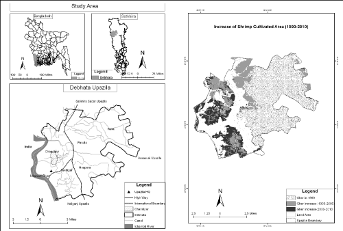
Figure 1 & 2: Study Area with Shrimp Farming
Conclusion and Recommendations
The study area is one of sites where local environment has been heavily damaged due to shrimp production. Saline water intrusion in the study area has caused colossal negative effects to the local vegetation and particularly to production of rice and vegetables. Due to continuous shrimp farming the level of EC has remarkably increased in lower depth of gher soil affecting soil productivity. Insoluble materials from food inputs in the shrimp ponds have been prevalent to a large magnitude causing high level of water contamination. Saline water in the gher being stagnant for a long time allows toxic substances to settle in the gher soil. The local people are ultimately under severe health risks as a result of extensive shrimp farming. Therefore, the widespread practices of shrimp cultivation in the south-eastern and south-western parts of the country are likely to bring severe damages to local ecosystems.
The present research reveals that an immediate step is essential to stop the further degradation of local environment. Saline water being destructive to local freshwater sources, the level of salinity has to be maintained in gher water for better production and environmental sustainability. Proper drainage system needs to be introduced to maintain water quality and discharge effluents from ghers. Saline tolerant rice and other crops may be introduced in shrimp cultivated area. Moreover, measures to control the use of fish-feed have to be adopted. Sustainable shrimp cultivation should be maintained to ensure social, economic and ecological stability. Above all, scientific research initiatives have to be undertaken in order to identify better solutions of environmental issues induced by shrimp cultivation.
Acknowledgement
Laboratory experiments of soil and water were carried out in the Environmental Laboratories of the Dept. of Geography and Environment, Department of Soil, Water and Environment, University of Dhaka, and Bangladesh Council for Scientific and Industrial Research, Dhaka. The two institutions are gratefully acknowledged for the generous supports for the experiments. Special thanks to Professor Dr. Sirajul Hoque, Department of Soil, Water and Environment, University of Dhaka.
References