
Research Article
Austin J Aquac Mar Biol. 2014;1(1): 3.
Increasing Bimodality of Monthly Precipitation Values for 4-30 Year Normals for Lajas Puerto Rico during the 1947-2006 Period
Kubaryk JM*
Department Marine Sciences, University of Puerto Rico, USA
*Corresponding author: Kubaryk JM, Department Marine Sciences, University of Puerto Rico, PO Box 5000 Mayaguez PR 00681, USA.
Received: September 05, 2014; Accepted: November 07, 2014; Published: November 15, 2014
Abstract
While finding that the Lajas annual rainfall was normally distributed with a strongly marked bimodal rhythm was expected finding that the progression of the four-thirty year "Normals" was increasing in their bimodality as seen by its distribution becoming more symmetric was surprising. The 1947-76 "Normal" had an early peak in April and a late peak September, with the latter being some 4.06 inches greater than the former. In the 1957-86 "Normal" the early peak shifted to May while the late peak was unchanged but the difference between the two decreased to 2.54 inches. In the 1967-96 "Normal" the early peak was unchanged but late peak shifter to October and the difference between the two peaks decreased to 2.34 inches. Then in the 1977-06 "Normal" the peaks were unchanged but the difference had shrunk to just 1.47 inches.
Keywords: Rainfall; 30-year normals; Increasing bimodality
Introduction
As the smallest and easternmost of the Greater Antilles, Puerto Rico's insularity and extremely complex geographic structure result in numerous mesoclimates that are primarily due to the effect that the three major cordilleras have in producing diverse rainfall regimes over very small areas [1]. With the island consisting of mainly (about 75%) mountains and hills with extensive (about 25%) coastal plain areas in the north and east most of its rainfall is orographic [2]. During May to November, precipitation is produced mainly by moisture laden easterly trade winds being forced over the major cordilleras producing disturbances that vary from low-intensity systems accompanied by little or no rainfall, to intense systems produced from African easterly waves that can produce torrential rains or hurricane flooding, most commonly from mid-June to early October [3-5]. Then during November to April, slow moving northern cold fronts that can penetrate far enough south to affect the island can produce significant precipitation that will generally occur intermittently over several days. Additionally, Puerto Rico's atmosphere is nearly always convectively unstable [6] so given that its north coast is a broad plain that rises in a gentle slope toward the interior, while the south coast is a narrow coastal plain that rises steeply toward the Cordillera Central the spatial and temporal rains that develop are generally larger in the northern and mountain areas than in the southern regions. Since these events are due to local features they are generally of short duration but can be relatively intensive events.
The Lajas Agricultural Experimental Station is geographically located at 18 3 N latitude and 67 3 W longitude, is situated on the leeward side of the central mountain range relative to the trade winds that generally have strong east and northeast components and, as such, is subject to a rain shadow affect [7]. Lajas has just two seasons characterized by meteorological or climatic conditions, rainy and dry [8]. The relationship between large-scale atmospheric circulation and the annual precipitation pattern in the Caribbean basin has been well studied and shows a distinct bimodal behavior [9,10]. The shift in the position and intensity of the Inter-Tropical Convergence Zone (ITCZ) and Vertical Wind Shears (VWS) are the principal contributors to the development of this pattern [10,11]. In Lajas the dry winter months (DWM - December thru March) are followed by a short first mode called the Early Rainfall Season (ERS - April-May), that is succeeded by a Mid-Summer Drought (MSD - June-July), that is followed by a longer second mode the Late Rainfall Season (LRS - August thru November) [12-14] reported that the MSD is significantly related to VWS and greater amounts and larger size of aerosols (Saharan dust) that inhibit droplet production resulting in greater cloud cover but less precipitation. The MSD appears in early June in Puerto Rico and Hispaniola as a result of the North Atlantic Subtropical High (NASH) and serves as a break between the two rainy seasons which have maxima that are some 3 to 4 months apart [15-17]. In August as the ITCZ shifts from the equator to its most northerly position coincides with the LRS [11] that lasts until the end of hurricane season.
Materials and Methods
For this study the data used was the monthly precipitation observations for 1947-2007 as reported in inches by the designated employee at the Lajas (NOAA-665097) meteorological station. This explains why data that is not available from NOAA for the years 1947 and 1962 and several miscellaneous months were included here. All data was analyzed using traditional normative statistical descriptions of precipitation variability (Tables 1 and 2).
![]()
    Jan.
    Feb
    March
    April
    May
    June
    July
    Aug
    Sept
    Oct
    Nov
    Dec


    Mean
    2.09
    1.71
    1.99
    3.31
    4.17
    2.54
    3.38
    5.47
    6.45
    6.31
    4.98
    2.72


    SD
    1.81
    1.48
    1.64
    2.31
    3.41
    2.05
    2.01
    2.88
    3.80
    3.83
    3.42
    1.97


    CV
    86.63
    86.51
    82.48
    69.77
    81.62
    80.51
    59.59
    52.68
    58.97
    60.71
    68.55
    72.47


    Max
    10.27
    7.84
    9.78
    13.01
    14.70
    9.62
    8.92
    16.05
    19.53
    20.56
    19.13
    10.37


    Min
    0.01
    0.02
    0.08
    0.24
    0.00
    0.00
    0.36
    1.39
    0.96
    1.43
    0.07
    0.14


    Median
    1.56
    1.27
    1.59
    3.07
    3.27
    2.11
    2.77
    5.07
    5.77
    5.92
    4.44
    2.10


    Skewness
    1.92
    1.70
    2.18
    1.51
    1.20
    1.33
    0.90
    1.51
    1.16
    1.43
    1.76
    1.55


    Kurtosis
    5.84
    4.02
    7.70
    4.14
    1.12
    2.08
    0.04
    3.06
    1.48
    2.71
    4.73
    3.20
    Kurtosis


    1947-76 Normal
    2.13
    1.43
    1.76
    3.12
    3.05
    2.18
    3.75
    5.51
    7.18
    5.61
    4.40
    3.02
    -0.19


    1957-86    Normal
    1.95
    1.35
    1.48
    3.02
    4.13
    2.05
    3.10
    5.47
    6.67
    5.57
    4.88
    2.73
    -1.13


    1967-96    Normal
    1.88
    2.01
    1.93
    2.78
    4.39
    2.61
    2.89
    5.43
    6.20
    6.73
    5.68
    2.44
    -1.51


    1976-06    Normal
    2.05
    2.01
    2.23
    3.55
    5.41
    2.93
    2.92
    5.45
    5.69
    6.88
    5.61
    2.38
    -1.60
Table 1: Summary of monthly precipitation and 4-30 year "Normals" (in.) data for the Lajas station (1947-2006).
![]()
    Annual
    DWM
    ERS
    MSB
    LRS


    Mean
    45.11
    8.49
    7.49
    5.92
    23.21


    SD
    9.87
    3.47
    4.10
    3.26
    7.63


    CV
    21.89
    40.84
    54.83
    54.98
    32.87


    Max
    67.19
    19.47
    18.40
    14.97
    42.04


    Min
    25.17
    2.05
    0.45
    1.22
    6.94


    Median
    45.70
    8.14
    7.06
    5.05
    22.60


    Skewness
    0.15
    0.83
    0.54
    0.96
    0.45


    Kurtosis
    -0.36
    0.86
    -0.02
    0.32
    -0.11


    1947-76    Normal
    43.13
    8.39
    6.17
    5.93
    22.70


    1957-86    Normal
    42.37
    7.55
    7.14
    5.15
    22.59


    1967-96    Normal
    44.94
    8.25
    7.17
    5.50
    24.04


    1977-06    Normal
    47.11
    8.62
    8.96
    5.85
    23.64
Table 2: Summary annual and seasonal precipitation and 4-30 year "Normals" (in.) data for the Lajas station (1947-2006).
Results and Discussion
All months have positive skewness and kurtosis value with June having the lowest and January the largest (Table 1).The percentages of seasonal precipitation compared with annual precipitation are: 51% for LSR (August thru November), 19% for DWM (December-March), 17% for ERS (April-May) and 13% for MSB (June-July). The main characteristics are a significantly greater (P<0.05) precipitation rate during LSR, and while all four seasons are positively skewed MSD, at 0.961 and DWM at 0.821 are nearly twice those of LSR, at 0.454 and ERS, at 0.539; the kurtosis values for LSR and ERS are negative, -0.106 and -0.019, while MSD and DWM are positive, 0.857 and 0.329, respectively (Table 2).
The WHO (1986) considers thirty years long enough to eliminate year-to-year variations and these values are called "Normals" that are generally updated at the end of each decade and are used as a base against which to compare current climate conditions. The 1947-2006 data allows for four "Normals" to be produced that demonstrated a surprising progression towards increasing bimodality as kurtosis values increased from -0.19 to -1.60, along with a general trend towards increasing monthly and annual rainfall, but there were some discrepancies (Table 1, Figure 1). The months of January and August each remained relatively unchanged for all four "Normals", while the averages for July, September and December were found to mostly decrease through time and the 1977-06 values were some 21-22% lower than the values for the 1947-76 period. The May average rainfall values for the 1947-76 period was significantly (P<.05) less than the long term average while the 1987-06 average was significantly (P<.05) greater than the long term average (Table 1). The 1947-76 "Normal" had an early peak in April and a late peak September, with the latter being some 4.06 inches greater than the former. In the 1957-86 "Normal" the early peak shifted to May while the late peak was unchanged but the difference between the two decreased to 2.54 inches. In the 1967-96 "Normal" the early peak was unchanged but late peak shifter to October and the difference between the two peaks decreased to 2.34 inches. Then in the 1977-06 "Normal" the peaks were unchanged but the difference had shrunk to just 1.47 inches. With the exception of the ERS, which includes the month of May and has undergone a persistent trend of greater precipitation that is significant, the other three seasons evolved weakly bipolar movements. These tendencies were toward peak decreases in precipitation in the 1956-86 "Normal" that was significant only for the DWM season, and then have relatively greater rainfall with the MSD season being the only one with precipitation below its long term average for the 1987-06 "Normal". However, the June rainfall during the 1987-06 "Normal" was one-third greater than the 1947- 76 "Normal" while July cohorts' values decreased some 20% over the same periods.
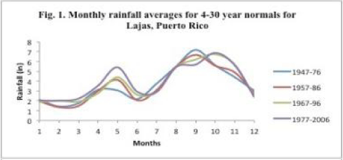
Figure 1: Monthly rainfall average for 4-30 year normals for Lajas, Puerto Rico
Conclusion
The reason for comparing the "Normals" precipitation is to provide some information on the different tendencies according to the month, seasonality, and annual events. That the annual rainfall was normally distributed with a typical strongly marked bimodal seasonal rhythm for Lajas was expected, since it has been reported to generally occur in the Caribbean by many, including Giannini et al. (2001) and Chen and Taylor (2002); however, what has not been reported is the rhythm for Lajas is increasing in its bimodality as seen by its distribution becoming more symmetric, which is demonstrated in an increasingly negative kurtosis value as the "Normals" moved from 1976 through 2006 (Table 1). When dealing with data that is normally distributed, like rainfall, increasing negatively of kurtosis would indicate broader distribution and [18] stated that a perfectly bimodal distribution of measures has a value of -2.00. Using mesoscale land use changes on and around the Lajas station to explain changes in rainfall are not justifiable since these have been, at most, minimal, and synoptic events appear to be capable of explaining, in part, just the wet and dry extreme rainfall events, that occur both seasonally and annually. As such, uncoupling the trend of increasing bimodality of Lajas precipitation that is seen in the progression in the four "Normals" from the physical processes causing it is not fully possible with the data that informs this study.
References
- Howarth, MD. Climatic Studies of Puerto Rico. [M.S] Department of Geography; Clark University, Worcester, MA. 1934.
- Pico R. The Geography of Puerto Rico, Aldine Publishing, Chicago, IL 1974.
- Burpee RW. The origin and structure of easterly waves in the lower troposphere of North Africa. J. Atmos. Sci.1972; 29: 77-90.
- Norquist DC, Recker EE, Reed RJ. The energetics of African wave disturbances as observed during Phase III of GATE. Mon Wea Rev. 1977; 105: 334-342.
- Reed RJ, Nordquist DC, Recker EE. The structure and properties of African easterly wave disturbances as observed during Phase III of GATE. Mon. Wea. Rev. 1977; 105: 317-333.
- Riehl H. Diurnal variation of moisture and stability aloft in the vicinity of San Juan, Puerto Rico. Bull AmMeteorol Soc. 1947; 28:137-143.
- Smedley, D. Climates of the states. Puerto Rico and the U.S. Virgin Islands. Climatography of the United States No. 60-52. U.S. Department of Commerce, NOAA. 1961.
- Capiel, M, Calvesbert, RJ. On the Climate of Puerto Rico and itsAgricultural Water Balance. J. Agric. Univ. Puerto Rico. 1976; 60:139-153.
- Cry GW, Haggard WH. North Atlantic tropical cyclone activity, 1901-1960. Mon. Wea. Rev. 1962; 90:341-349.
- Gray WM. Global view of the origin of tropical disturbances and storms. Mon Wea Rev. 1968; 96:669-700.
- Etter PC, Lamb, PJ, Potis, DH. Heat and freshwater budgets of the Caribbean with revised estimates of the Central American seas. J Physical Oceanography. 1987; 17: 1232-1248.
- Giannini A, Kushnir Y, Cane MA. Seasonality in the impact of ENSO and the North Atlantic high on Caribbean rainfall. Phys Chem Earth. 2001; 28: 143-147.
- Chen AA, Taylor M. Investigating the link between early season Caribbean rainfall and the El Nio. Int J Climatol. 2002; 22: 87-106.
- Angeles ME, González JE, Ramirez-Roldan N, Comarazamy DE, Tepley, CA. Origins of the Caribbean rainfall bimodal behavior. Proceedings from the 87th American Meteorological Society Annual Meeting, San Antonio. 2007.
- Giannini A, Kushnir Y, Cane MA. Interannual variability of Caribbean rainfall, ENSO, and the Atlantic Ocean. J Clim. 2000; 13: 297-311.
- Gamble DW, Parnell DB, Curtis S. Spatial variability of the Caribbean mid-summer drought and relation to the North Atlantic High. Int J Climatol. 2007; 28: 343-350.
- Curtis S, Gamble DW. Regional variations of the Caribbean mid-summer drought. Theoretical and Applied Climatology. 2008; 94: 25-34.
- Chissom BS. Interpretation of the kurtosis statistic. The Amer. Statistician. 1970; 24: 19-22.